


GPX Photo search
Deskripsi GPX Photo search
"GPX photo search" is Android app to search for photos taken in journey from the photo that is stored in the smart phone or Google photo.
Since the search in the shooting time even if you do not have organize your photos, have been recorded, is a Hassle
********************************************
I do not support writing geotag of external SD card on Android 4.4+.
I think that there is no choice but to copy the files to internal storage and process them.
********************************************
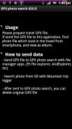
To use later, is required track log data (GPX file) were recorded leg of a journey.
This will make a move if you record GPS logger app.
(The GPS logger app, and you have Mountain trip logger)
In GPX photo search, use time of the track log and time the picture was taken (Exif) to find the photo data
※This free version shows ad at screen top. GOLD is ad-free version.
◆ How to use
Please send track log file (GPX) to GPX photo search.
[How to send]
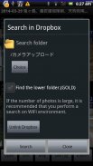
・Place the SD card the GPX file, the file manager application (ES File Explorer, such as AndExplorer) to send
・In Mountain trip logger, press and hold the data you want to use the measurement results list screen, send in the form of share-GPX
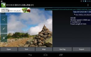
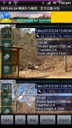
Then, the search will begin the photo. View photos from the SD card to find a smartphone, that are found.
Display mode is switched to tap the screen, you can turn off the button and find more information and get out.
If a photo does not appear that there should be a photo but if, it may be funny to set the folder that you want to search for photos.
From Menu, setting, please try to change the settings of the folder you want to search.
Models also have built-in SD cards such as the Galaxy in particular areas, you may need to be changed.
▼ function (1) View photos every time
I think the camera is handy and they accumulated a lot of photos taken in various places.
And accumulate a lot, is very well to organize manually later.
However, it is all right if and when the track log data was taken, and GPX photo search.
Search even if they are not organized a photo, you can browse every time, you can output to a file.
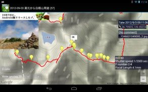
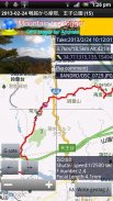
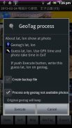
▼ function (2) Set the Geotagging Photos
As how to use slightly more advanced, the photo (geo) has not been set location information, you can also set a geotag.
(Measures of location information leakage) in the camera settings you think in many cases have taken off and then recording the geotag.
Even in such a case, fine, if the data and track logs when taken, the GPX photo search.
You can set the photo geotagging to estimate the latitude and longitude of the position taken by matching the track log time and the picture was taken, does not have a geotag.
The advantage of setting up as geotagging, apps and services that support geotagging: In (eg Picasa), you can put your photos on the map string.
Do not know when I look back later, be a more vivid memories.
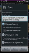
▼ function (3) Output file
It is for people who have a PC primarily, can be output to a file and search photos.
-Format ZIP (image)
Outputs a file all images taken in the journey. Can be used to take a backup on your computer, such as
-Format GPX (waypoints)
Gpx file that outputs the way point to point and shoot. You can import a point in compatible software.
-Format KMZ (track log + points + reduced image)
Outputs the data points with a track log and photos of stroke, are listed on the map. You can import in Google Earth
▼ function (4) Live wallpaper
Show photos as live wallpaper.
▼ function (5) Upload to Yamareco
http://www.yamareco.com/
"Pencarian foto GPX" adalah aplikasi Android untuk mencari foto yang diambil dalam perjalanan dari foto yang disimpan di ponsel pintar atau foto Google.
Karena pencarian di waktu pemotretan bahkan jika Anda tidak mengatur foto Anda, telah direkam, adalah kerumitan
******************************************
Saya tidak mendukung penulisan geotag kartu SD eksternal di Android 4.4+.
Saya pikir tidak ada pilihan selain menyalin file ke penyimpanan internal dan memprosesnya.
******************************************
Untuk menggunakannya nanti, diperlukan data trek log (file GPX) yang direkam sepanjang perjalanan.
Ini akan bergerak jika Anda merekam aplikasi GPS logger.
(Aplikasi GPS logger, dan Anda memiliki logger trip Gunung)
Dalam pencarian foto GPX, gunakan waktu track log dan waktu gambar diambil (Exif) untuk menemukan data foto
※ Versi gratis ini menampilkan iklan di bagian atas layar. GOLD adalah versi bebas iklan.
◆ Cara menggunakan
Silakan kirim file log lagu (GPX) ke pencarian foto GPX.
[Bagaimana cara mengirim]
・ Tempatkan kartu SD file GPX, aplikasi manajer file (ES File Explorer, seperti AndExplorer) untuk dikirim
・ Di Mountain trip logger, tekan dan tahan data yang ingin Anda gunakan layar daftar hasil pengukuran, kirim dalam bentuk share-GPX
Kemudian, pencarian akan memulai foto. Lihat foto dari kartu SD untuk menemukan smartphone, yang ditemukan.
Mode tampilan diaktifkan untuk mengetuk layar, Anda dapat mematikan tombol dan menemukan informasi lebih lanjut dan keluar.
Jika suatu foto tidak muncul bahwa harus ada foto tetapi jika, mungkin lucu untuk mengatur folder yang ingin Anda cari foto.
Dari Menu, pengaturan, silakan coba ubah pengaturan folder yang ingin Anda cari.
Model juga memiliki kartu SD bawaan seperti Galaxy di area tertentu, Anda mungkin perlu diubah.
Fungsi ▼ (1) Lihat foto setiap saat
Saya pikir kameranya berguna dan mereka mengumpulkan banyak foto yang diambil di berbagai tempat.
Dan menumpuk banyak, sangat baik untuk mengatur secara manual nanti.
Namun, tidak apa-apa jika dan ketika data log trek diambil, dan pencarian foto GPX.
Cari bahkan jika mereka tidak mengatur foto, Anda dapat menelusuri setiap kali, Anda dapat menampilkan ke file.
Fungsi ▼ (2) Mengatur Foto Geotag
Seperti cara menggunakan sedikit lebih maju, foto (geo) belum mengatur informasi lokasi, Anda juga dapat mengatur geotag.
(Ukuran kebocoran informasi lokasi) dalam pengaturan kamera yang Anda pikir dalam banyak kasus telah lepas landas dan kemudian merekam geotag.
Bahkan dalam kasus seperti itu, baiklah, jika data dan lacak log saat diambil, cari foto GPX.
Anda dapat mengatur geotagging foto untuk memperkirakan garis lintang dan bujur dari posisi yang diambil dengan mencocokkan waktu log trek dan gambar diambil, tidak memiliki geotag.
Keuntungan dari pengaturan sebagai penandaan geografis, aplikasi dan layanan yang mendukung penandaan geografis: Dalam (misalnya Picasa), Anda dapat meletakkan foto Anda di string peta.
Tidak tahu kapan aku melihat ke belakang nanti, jadilah kenangan yang lebih hidup.
Fungsi ▼ (3) Output file
Ini untuk orang-orang yang memiliki PC terutama, dapat menjadi output ke file dan mencari foto.
-Format ZIP (gambar)
Menghasilkan file semua gambar yang diambil dalam perjalanan. Dapat digunakan untuk mengambil cadangan di komputer Anda, seperti
-Format GPX (titik arah)
File Gpx yang menampilkan cara point to point dan menembak. Anda dapat mengimpor titik dalam perangkat lunak yang kompatibel.
-Format KMZ (track log + poin + gambar dikurangi)
Output poin data dengan track log dan foto stroke, tercantum di peta. Anda dapat mengimpor di Google Earth
Fungsi ▼ (4) Wallpaper hidup
Tampilkan foto sebagai wallpaper hidup.
Fungsi ▼ (5) Unggah ke Yamareco
http://www.yamareco.com/
GPX Photo search - Versi 8.3
(06-03-2023)GPX Photo search - Informasi APK
Versi APK: 8.3Paket: com.kamoland.gpxpsearchVersi Terakhir dari GPX Photo search
Versi lain


Aplikasi pada kategori yang sama

Anda juga mungkin suka...


